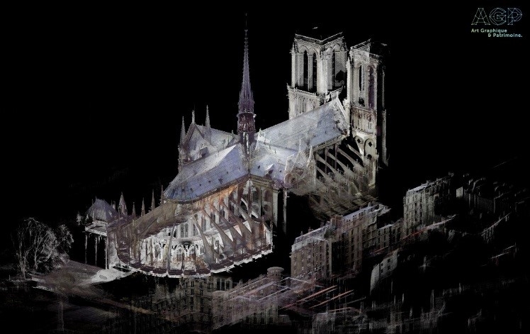
On Saturday, 20th April 2019, the AGP (Art Graphique & Patrimoine) team joined forces with FARO (NASDAQ: FARO), world leader in 3D imaging and measurement technology for Building Information Modelling (BIM), to carry out an emergency initiative to help save Notre-Dame. Conducted in just one day, this initiative involved carrying out a highly accurate 3D survey of the building in its post-fire state in order to assess the extent of the damage.
he data collected during these initial post-disaster 3D surveys using the most advanced laser scanners from the FARO Focus S series can now be compared to AGP’s data from before the fire, thus providing useful information for the reconstruction process and ongoing investigation.
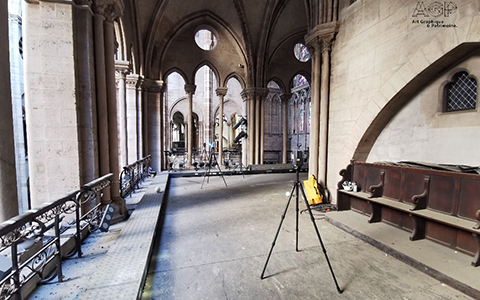
FARO equipment in the Notre-Dame ©Art Graphique & Patrimoine
All of this data will allow everyone involved in the reconstruction process to access a reliable corpus of technical documents, 3D measurements and images. The purpose of that Saturday’s initiative, known as ‘Operation Commando’, was to digitally map the entire cathedral, especially the parts that were most severely damaged. A week’s worth of work was accomplished in just one day thanks to the hard work of the AGP team and the FARO laser scanners. Taking into account the exceptional circumstances, FARO loaned its Focus S laser scanners to the digital mapping experts free of charge: this equipment has been used by AGP for more than 15 years and is perfectly suited for surveying our architectural heritage.
FARO’s Laser Focus S scanner is both quick and powerful, the ideal tool for performing laser surveys in the area of architecture, BIM and heritage conservation. Extremely portable, it allows the user to directly survey façades and complex structures at speed and with precision, combining extremely accurate digital mapping technology with unrestricted ease of use. Reliable and flexible, the scanner allows you to view the recorded data in real time. The mapped data can then be easily imported into FARO’s software solution, SCENE 2019, to access the 3D surveys and reconstruction models.
During this one-day operation, colour scans were taken from more than 300 positions, amounting to approximately 30 to 40 billion points. The inaccessible parts of the cathedral were mapped by means of photogrammetry using a drone.
This data will be used to assess the damage caused by the fire so as to ascertain which parts are most severely affected. This first stage of the reconstruction process is essential to saving the cathedral. Our teams are now working to process this mass of data (this involves assembling and consolidating the scans to form a complete point cloud, colourisation, and comparison with the pre-existing data).